
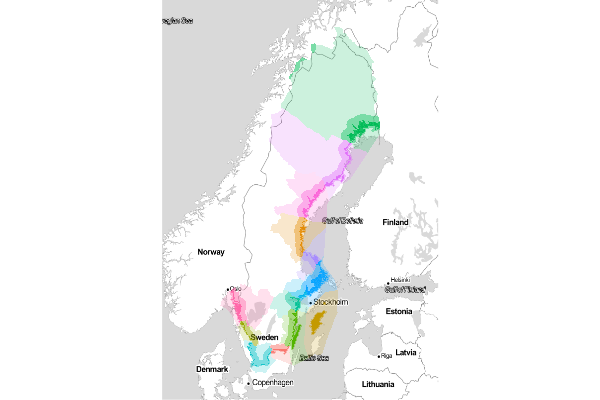
Regions are the fundamental spatial units of analysis for the Ocean Health Index. Scores are calculated for each region individually and then combined (with an offshore area-weighted average) to produce scores for the entire study area: Sweden. These template regions can be modified; they were identified as the largest subcountry division within Sweden.
Or see the interactive map of the offshore regions on Github.
OHI Sweden has the following subcountry regions, each with a unique identifier (ID):
| ID | NAME |
|---|---|
| 0 | Sweden |
| 2 | Blekinge |
| 11 | Gävleborg |
| 5 | Gotland |
| 4 | Halland |
| 3 | Kalmar |
| 14 | Norrbotten |
| 7 | Östergötland |
| 1 | Skåne |
| 8 | Södermanland |
| 9 | Stockholm |
| 10 | Uppsala |
| 13 | Västerbotten |
| 12 | Västernorrland |
| 6 | Västra Götaland |
IDs for subcountry regions were assigned geographically by increasing longitude. The entire study area (Sweden) has a special region ID of 0.
Exclusive economic zones (EEZs) were identified by www.marineregions.org/ and the largest subcountry regions were identified by gadm.org. Region boundaries were extended offshore to divide the EEZ of Sweden offshore regions. It is possible to use different regions than the ones provided here: see ohi-science.org/pages/create_regions.html for more details.
Regions were generated with the following inland and offshore buffers relative to the shoreline, which are visualized in the graphic above within increasing opacity away from the shoreline.
- offshore
- offshore1km
- offshore3nm
- inland
- inland1km
- inland25km
These data are available as shapefiles as well as csv files summarizing total area per region. Since shapefiles are binary and can be large, they're best stored outside the swe Github repository. Instead, download the zipped set of shapefiles: